Matabeleland South braces for floods as downgraded Cyclone Dineo approaches
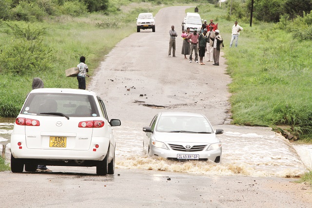
Motorists cross a flooded Phekiwe River in Umguza near Bulawayo
Nqobile Tshili/ Austin Nyathi, Chronicle Reporters
THE southern parts of the country are expected to experience severe flooding beginning today due to a tropical storm that entered the country last night, the Meteorological Services Department (MSD) said yesterday.
The areas likely to be hit include Bulawayo, Masvingo, Matabeleland North, Midlands, and Matabeleland South provinces. They will, however, no longer experience Cyclone Dineo as earlier feared but a violent tropical storm. The downgrading of Cyclone Dineo was caused by the decrease in wind speeds from a range of 120-150 kilometres per hour (km/h) as recorded in Mozambique to between 60 to 80km/h in the country.
The winds will continue to decrease as the storm heads westwards into Botswana where its speeds will reduce to between 40km/h to 50km/h.
Regional media reports yesterday depicted widespread destruction caused by the weather phenomenon in parts of Southern Africa, claiming four lives in Mozambique, ravaging property and leaving scores of people homeless.
In an interview yesterday, MSD senior forecaster Mr Tich Zinyemba said intense flooding characterised by strong winds ranging between 60km/h to 80km/h should be expected in the southern region of the country.
“We’re saying it (tropical storm) has now entered the country. It’s affecting areas to the south. It has entered the country through the south of Masvingo province and areas that are going to be affected include Chiredzi, Mwenezi, the whole of Matabeleland South, part of the Midlands, migrating into Matabeleland North, Nyamandlovu and even Bulawayo,” said Mr Zinyemba.
“We’re saying it will pick its activities and should continue to affect the southern areas tomorrow (today) at its peak and we’re looking at fairly strong winds. At the moment it has downgraded to a tropical storm from a tropical cyclone but it is still intense. We’re looking at wind speeds of 60 to 80 kilometres per hour.”
Mr Zinyemba said heavy floods that should not be taken lightly will be experienced.
He said people in the traditionally flood-prone areas like Tsholotsho should move to higher ground.
“Areas such as Tsholotsho are going to be impacted upon. In areas like Sipepa people should be on the lookout for flooding,” he said.
“As the storm moves overland westwards into Botswana we expect the wind speeds to be 40km per hour,” he said.
In Matabeleland South, the Civil Protection Unit (CPU) yesterday advised school heads to stop children from going to school today as fears of life-threatening floods heightened.
CPU provincial chairperson Mrs Sithandiwe Mafu told participants at the Provincial Administrator’s boardroom yesterday that they will assess the situation on Sunday to see if it was safe for children to attend lessons next week.
“We would like to advise school heads to stop children from going to school on Friday (today) while we assess the situation regarding the impending cyclone that is set hit our province.
“Members of the public should not cross flooded rivers and where possible they should guard their property and stay indoors,” said Mrs Mafu.
She said people should call toll free number 0284 20129 if they encounter problems.
About two weeks ago, a total of 13 people were marooned at West Nicholson in Matabeleland South and had to be rescued by a helicopter from Bulawayo.
The country has experienced serious flooding this season which has resulted in some roads being impassable, washing away bridges in the process.
Some people have lost their lives while trying to cross flooded rivers while in some areas pupils were no longer attending school due to the heavy rains.
— @nqotshili


You Might Also Like
-
Zvamaida Murwira in Murambinda EDUCATION, through science and technology, is a tool of national development and economic growth that all children should embrace in line with the country’s economic blueprint, the National Development Strategy 1, President Mnangagwa has said. Addressing a Children’s Party here ahead of today’s 44th National Independence Day commemorations, President Mnangagwa said […]


Agriculture Journal


Comments