The pipeline that its detractors call a pipedream
Jonathan Maphenduka
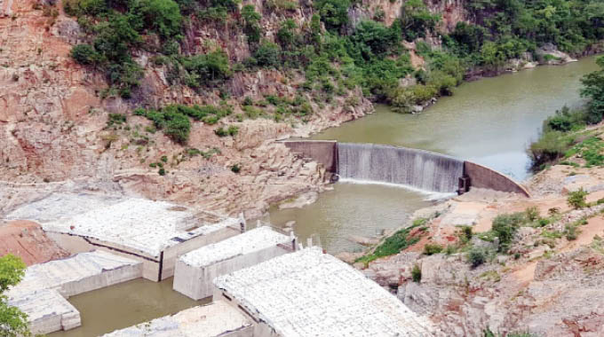
IN December 1992 Joseph Msika who was then minister responsible for water development, announced that Government had plans to build a pipeline from Lake Kariba to Kudu in the rich Kadoma District which would be extended to Ncema Dam as part of Government’s initiative to alleviate water woes that affected the city of Bulawayo.
The region of Matabeleland, led by the city’s civic authority, the Bulawayo City Council, had for years now been pushing for construction of the proposed Matabeleland Zambezi Water Project (MZWP) pipeline project which had been on the drawing board since 1912.
In December 1991 a meeting of frontline states in Kasane, Botswana, decided to turn down a bid by South Africa to draw water from Kazungula to the republic’s dry north western region. The rejection of South Africa’s application came despite the republic’s offer to build a spur pipeline from Francistown to Bulawayo as a trade-off.
After the Kasane meeting, a civil servant (it’s not politic to name him) issued a statement criticising those behind the MZWP “when there are so many suitable dam sites around the city of Bulawayo”.
When Msika announced the plans to extend the projected Kariba-Kudu-Ncema pipeline, he also put completion of the projected MZWP project ahead of the Tugwi-Mukosi Dam project. This contradicted Government policy which in fact was against development of the MZWP pipeline. Amid public statements describing the proposed project as “a pipedream”, it became clear that Msika’s statement was in fact a sop to divert attention away from the MZWP pipeline.
One development that occurred amid the contraditions was that the Bulawayo City Council found itself (out of budget) having to construct the Nyamandlovu Aquifer-Magwegwe pipeline to avert disaster.
The declaration that there were several suitable dam sites around Bulawayo was in fact misleading because there was no mention of their location and the situation has remained the same since the statement was made in 1991.
Since then there has been concerted efforts to stall completion of a pipeline offer to the city from Mtshabezi Dam as additional supply dam for Bulawayo, and this idea has in fact been given force by the construction of a pipeline from the dam to Umzingwane Dam.
However, Mtshabezi Dam for intents and purpose belongs to Gwanda. On the other hand Umzingwane Dam, with its limited catchment area, is the most unreliable source of water for the city of Bulawayo.
It is imperative, therefore, that the people of Matabeleland must push for the speedy completion of the Gwayi-Shangani Dam. The people of Matabeleland would be well-advised to devote their energies on pushing for completion of the Gwayi-Shangani Dam instead.
There are several compelling reasons for this approach. One of these is the effect of climate change which renders the Zambezi as an increasingly unreliable source of water.
The Zambezi River is an international water basin, with Zimbabwe enjoying a relatively small amount of its water. From Kazungula to Tete, Zimbabwe enjoys only 36 percent of the water with the rest going to Zambia.
It is, moreover, imperative that the region of Matabeleland should spare no effort to push Government to identify those dam sites around the city that have been a subject of so much empty talk over the years. These are Government potential sites it said could be developed to improve water supplies for the region’s cities, with spare water for irrigation. We have heard for years how the MZWP would create a greenbelt along the pipeline. This is still achievable because Government is obligated to keep its promises to the people of this region.
Moreover, truncating the MZWP on the confluence of the Shangani and Gwayi rivers does not seriously affect the region’s inflows into the Zambezi River which protects the region’s right on the common basin which is the Zambezi River.
The region will further be adequately compensated by the construction of the proposed Batoka Gorge Hydroelectric dam project. Feasibility studies for this project (according to the Zambezi River Authority) will yield twice the amount of electricity than that of Kariba South and Kariba North put together. This will ensure that energy supply from Batoka will be secured for all time, barring only an act of God which can disrupt security of supply.
This means that power needs for the development of the region will be secured. Let me mention that international protocols ensure that national riparian rights are protected. completion of the Batoka Gorge project will ensure that the region’s electricity will be secured for many years after its completion.
Water development is a subject of perennial concern for some countries of the region. In the late 1990s Botswana was forced to construct a 400km dual carriage pipeline from Madinare near the mining town of Selebi-Pikwe to the capital Gaborone in record time.
South Africa years ago (before its ill-fated bid for Zambezi River water at Kazungula) signed an agreement with Joseph Mobutu Sese Seko to draw water from the Congo River, down the Kunene River, the boundary between Angola and Namibia, to the republic’s North-Western region.
This project has been affected by the on-going Inga hydroelectric project in which the Barack Obama administration in 2014 announced a project finance of a staggering US$7 billion. This is a Sadc project which is projected to light up the dark continent of Africa. African heads of state were invited to Washington (with Robert Mugabe the only one who was not invited) for the announcement.
South African president Jacob Zuma announced then that South Africa was ready to take a lion’s share of 50 percent of the project’s total yield.
The Congo River, whose source shares a watershed with the Zambezi River (without meeting) in Zambia’s Mwinilunga Province, is an incredible water basin.
It links in the east with Lake Banguelu, Chambeshi River and Luapula River in Zambia’s North Western Province. From Mwinilunga the Zambezi snakes in way in a south-westerly direction through Namibian marshlands for 250km before turning eastward into the marshlands of Barotseland, after which it becomes a flowing river on the way to Kazungula where Zimbabwe, Zambia, Botswana form a common boundary.
Caprivi is an enclave of Namibia which was created by Germany West Africa to access water from the Zambezi River, the longest river in Africa which flows east to the Indian Ocean. It is the fourth largest river in Africa.
Jonathan Maphenduka contact: 0772 332 404
You Might Also Like
-
ZIMBABWE on Wednesday joined the rest of the world to commemorate Workers’ Day, a day meant to pay tribute to workers’ contributions to the development of their respective countries. President Mnangagwa has hailed the country’s workers for their immeasurable contribution to economic development, describing the workers’ hard work as the backbone of Zimbabwe’s progress. Writing […]


Agriculture Journal


Comments